

Soil map of Maine.
 by Jude Hsiang
In recent weeks we’ve looked at the living creatures that make their homes in the soil. They ranged in size from microscopic to pocket size. Of course, there are larger animals who burrow in the soil for different reasons. A few of them might appear as we work in the garden, but others are careful to avoid us.
Three Maine mammals hibernate, two of them in the soil. Woodchucks and meadow mice sleep through winter in their dens. (The only other mammals that truly hibernate here are bats, who use the roosts they create in trees or caves, or the bat houses we make for them.) The other mammals snooze in a state of torpor but awaken on warm days to look for snacks. Black bears, skunks, porcupines, are among them.
Snakes share community dens. Most amphibians spend the winter under the frost line in the soil, but some can survive under the ice, just like fish. Wood frogs produce their own anti-freeze and thaw in the spring. Many animals make dens in the ground for protection from predators, especially when their young are the most tiny and vulnerable.
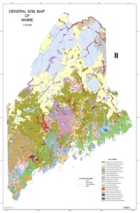
Of the two-legged creatures, besides farmers and gardeners, geologists are the most interested in soil. These scientists have studied Maine soils and rocks for hundreds of years and produced detailed maps.
A basic soil map of Maine focuses on three types of soils, based on the bedrock below. Glacial till s the name given to the soil that covers almost three-quarters of the states. This is the mix of sand, silt, clay – and all those rocks – left behind by the retreating glaciers. This soil is acidic, dense and relatively low in organic matter and fertility. A high amount of clay allows it to hold water but is subject to erosion. It’s what we find in most of central and northern Maine.
In the eastern and coastal parts of the state are podzolic soils which have a thick, acidic humus layer. This type of soil has a high level of organic matter, is very acidic. It has low fertility and nutrient content, but good drainage and aeration. It’s primarily found in York, Hancock, and Washington counties.
Marine soils are named for their coastal locations and have higher salt content and are more alkaline. They also have low fertility and nutrient availability, but good drainage. They are at risk of flooding and erosion because of their location. Marine soils are found in Knox, Lincoln, and Sagadahoc counties.
For the curious geologists three types of soil simply are enough. A soil map of Maine shows over two dozen soil kinds, named after the places they were first identified. The map looks like an accident in an ice cream parlor, with splotches of color. Vanilla for Telos-Monarda-Monson-Elliottsville. Peach for Swansville-Boothbay-Biddeford. Chocolate for Plaisted-Penquis-Thorndike-Howland. And more!
When we read the descriptions of our soils, we might wonder how anything at all can grow here. Yet the First People thrived by hunting and gathering, and later by farming as trade among indigenous people brought the Three Sisters – corn, beans, squash – all the way from the southern hemisphere. Maine has great forests and a variety of agricultural lands. Nature will provide if humans, observe, learn and protect.
© Judith Chute Hsiang
Jude Hsiang is a retired University Extension Master Gardener Program instructor and member of the China Community Garden.
Responsible journalism is hard work!
It is also expensive!
If you enjoy reading The Town Line and the good news we bring you each week, would you consider a donation to help us continue the work we’re doing?
The Town Line is a 501(c)(3) nonprofit private foundation, and all donations are tax deductible under the Internal Revenue Service code.
To help, please visit our online donation page or mail a check payable to The Town Line, PO Box 89, South China, ME 04358. Your contribution is appreciated!
Comments are closed.