
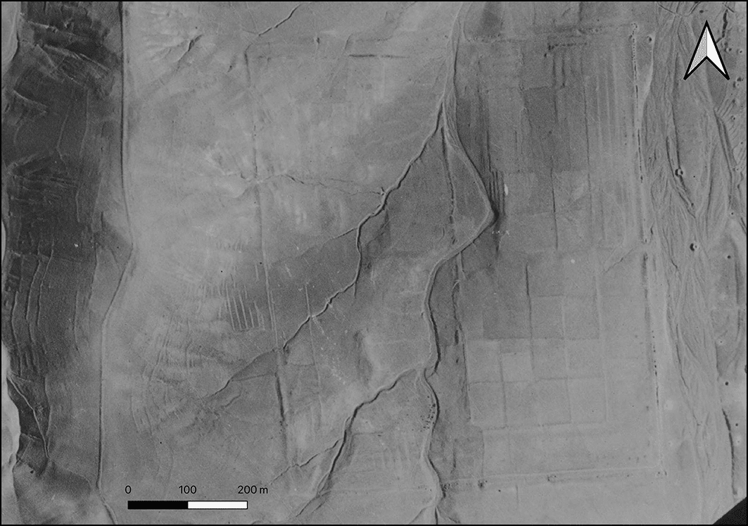
The garden site visible on georectified RAF photograph. Credit: Michael George Fradley et al. / CC BY-NC 4.0
Researchers say a vast, long-forgotten landscape once shaped the southern edge of historic Tabriz, long before modern roads and apartment blocks transformed the area. By analyzing declassified military aerial photographs and Cold War–era satellite images, the research team has identified traces of what appears to be a lost massive Persian garden complex. The remains lay hidden for decades beneath rapid urban expansion.
The images reveal a carefully planned landscape. Long straight lines, symmetrical divisions, and large enclosed spaces point to deliberate design rather than natural landforms. These features align with known principles of Persian garden architecture, which combined geometry, water, greenery, and built elements to shape ceremonial and symbolic spaces.
Researchers say the scale of the site is exceptional. If confirmed, the complex would rank among the largest monumental Persian gardens ever identified in Iran. Its size suggests it was not a private retreat, but a major designed landscape tied to elite, political, or civic life.
How old images revealed a vanished site
Most visible traces of the site have vanished. Since the early 1990s, the area has been covered by dense housing, highways, and modern infrastructure. That made a traditional archaeological survey nearly impossible. Remote sensing offered one of the few ways to reconstruct the earlier landscape without excavation.
The findings were published online on January 30, 2026, by Cambridge University Press as part of the Endangered Archaeology in the Middle East and North Africa initiative. The project is led by scholars from the University of Oxford, the University of Leicester, and Durham University, with funding from the Arcadia Fund.
The site lies about six kilometers southeast of historic Tabriz. While little remains visible today, earlier imagery tells a different story.
Wartime photos and Cold War satellites
Researchers examined reconnaissance photographs taken by the Royal Air Force in August 1941, during the Anglo-Soviet invasion of Iran. They compared them with U.S. KH-7 Gambit satellite images captured in 1967. Together, the images preserved a view of the land before large-scale urban growth erased its earlier form.
When digitally aligned and mapped using GIS technology, faint but consistent lines across the terrain came into focus. The pattern revealed a vast enclosed space with strong symmetry and internal organization. It stood apart from the irregular shapes typical of agricultural land.
A monumental garden takes shape
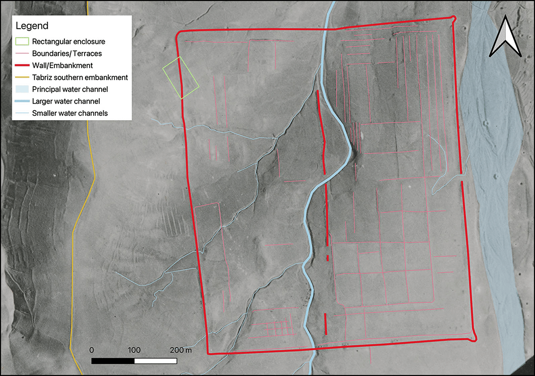
Basic mapping of the visible garden features. Credit: Michael George Fradley et al. / CC BY-NC 4.0
At its greatest extent, the complex appears to have covered nearly half a square kilometer. A substantial rectangular embankment enclosed the site. On the eastern side, researchers identified what appears to be a formal façade, marked by a central entrance and circular corner features resembling turret-like elements seen in elite garden architecture.
Inside the enclosure, the eastern half shows a strikingly regular layout. Rectangular garden plots are arranged in a grid, separated by low banks or walls. Individual plots measure roughly 50 to 55 meters by 65 to 75 meters. Along parts of the inner perimeter, long and narrow terraces, about 10 meters wide, run parallel to the enclosure, reinforcing the impression of careful planning.
A contrasting western landscape
The western half follows a different logic. It rises with the natural terrain and shows a looser arrangement. Small tributary channels feed into a winding watercourse, with fewer visible structural divisions.
Researchers interpret the contrast as intentional. The eastern zone may have served formal or ceremonial functions, while the western section likely emphasized the natural movement of water and landscape.
Water at the center of the design
Water appears to have played a central role in the garden’s layout. A meandering channel seems to divide the complex, while smaller streams shaped the western section. Unlike rigid canal systems seen in some later gardens, these watercourses appear largely natural, flowing with the contours of the land.
Researchers say this blend of strict geometry and freer water movement may reflect a regional adaptation of Persian garden traditions. They also suggest that a monumental building may once have stood on the elevated western ground, overlooking the formal garden plots below.
A wider garden landscape around Tabriz
The site lies only about 800 meters (0.5 miles) from El-Goli (Shah Goli), a well-known historic water garden dating at least to the early 18th century. Researchers believe the two sites may have formed part of a broader elite landscape on the outskirts of Tabriz.
Historical sources describe Tabriz as a city shaped by gardens as early as the 14th century, earning it the nickname “Garden City.” Texts and maps record major gardens such as Bagh-e Shomal and the Sahebabad Garden. No known source, however, mentions a garden of this scale at the newly identified location.
How it compares with Iran’s great gardens
Researchers compared the layout with famous Persian gardens elsewhere in Iran, including the Fin Garden in Kashan and the vast Hezar-Jarib Garden complex. While those sites are better documented or preserved, the newly identified Tabriz complex may have rivaled them in ambition.
Researchers say further study is needed. Ground surveys and targeted excavations could confirm the interpretation and clarify when the garden was built and how long it remained in use.
Even so, the discovery highlights how much of Iran’s cultural landscape may still lie hidden beneath modern cities—and how historical imagery can bring forgotten spaces back into view.
Comments are closed.